
SEARCH

By Craig Romano
Roundtrip: 9.6 miles
Difficulty: moderate
Elevation Gain: 1245 feet
High Point: 4200 feet
Best Season: early summer—fall
Trail Notes: You’ll need to purchase a Monument Pass (available at the Johnston Ridge Observatory) before beginning your hike. If starting before the observatory is open, carry your NW Forest Pass or Interagency Pass with you in lieu of the monument pass wristband. Dogs prohibited; off-trail travel prohibited. Always practice Leave No Trace Principles.
Trail Highlights: prolific and exceptional wildflowers, wetlands, excellent views of Spirit Lake and Loowit Falls
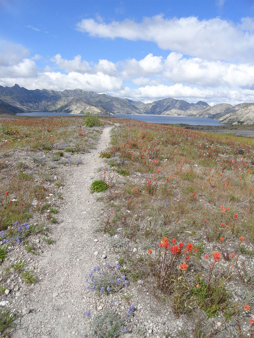
The Pumice Plain is one of the most spectacular features of the blast zone. Lying between the crater and Johnston Ridge, the plain was in essence sterilized of life after the lateral eruption in May of 1980. The intense heat of the pyroclastic flows killed everything on the plain. Consequently, plant recolonization has been much slower here than other parts of the Blast Zone.
Two years after the blast, Prairie Lupine began to grow on the barren plain. A nitrogen fixer, the Lupines aided in the colonization of other plant species. Today a good part of the plain is matted with grasses, willows and flowering plants. And come summer when these plants blossom, they provide for one of the best floral shows within the monument.
Nearly all of the plain is restricted to travel, but the Truman Trail traverses it not too far from Spirit Lake. You can reach the Pumice Plain from Windy Ridge by following the Truman Trail for 3.5 miles. This way requires a long road approach and a wet boot crossing of a spring-fed creek. The route via the Boundary Trail from the Johnston Ridge Observatory is longer and includes more elevation gain on the return than the Windy Ridge approach. But it is easier to get to; accessible earlier in the season; and is a much more scenic and exciting hike with its route along Johnston Ridge, through hummocks and around wetlands flourishing with life. And there are some great views of Spirit Lake and Loowit Falls along the way.
Hike: Starting on the Boundary Trail head east across Johnston Ridge. After climbing a tad, drop 200 feet to a saddle. The way then gradually climbs to bypass the Devil’s Elbow. Descend and enjoy great views of St Helens nearby and Adams in the distance. At 2.1 miles come to a junction with the Truman Trail in an area known as the Spillover, where landslide debris spilled-over the ridge during the 1980 eruption.
Now turn right and start descending off of the ridge on the Truman Trail. The trail was named for Harry Truman, a colorful curmudgeon and World War I vet who was the owner of the Mount St Helens Lodge at Spirit Lake. He refused to evacuate his property in the spring of 1980, responding; "If the mountain goes, I'm going with it.” He perished at age 83 along with his 16 cats during the eruption. The trail and nearby ridge above Spirit Lake are nice memorials to this man who became a folk hero to many.
Along the Truman Trail traverse a fascinating landscape of hummocks, small creeks, pocket wetlands, willow thickets and alder groves. The surroundings are harsh, soft, gray, green, and colorful. Approaching the Pumice Plain you’ll hike along ground that can be right out of South Dakota’s Badlands or California’s Mojave Desert—except for the new greenery. It’s an incredibly diverse topography that pre-eruption contained the North Fork Toutle River.
Trek across sandy terrain carpeted with wildflowers and come to a couple of ponds teeming with bird, insect, and amphibian life. Cross a couple of wide alluvial fans with creeks draining into Spirit Lake. With no outlet after the eruption, engineers bored a tunnel under Harry’s Ridge allowing water to flow into Coldwater Creek averting massive flooding and allowing for the lake to maintain a constant level.
The trail continues through willow thickets and crosses several more creeks. From the open plains enjoy excellent views into St Helens’ crater cradling Loowit Falls. There are excellent views too of the Mount Margaret peaks forming an imposing wall over Spirit Lake.
At 4.8 miles reach a junction with the Willow Springs Trail, a good point to turn around.
However, the Truman Trail continues beyond reaching the Windy Ridge Trailhead (an alternative starting point) in 2.0 miles.

Directions to Trailhead
From Castle Rock (Exit 49 on I-5) follow SR 504 east for 52 miles to its end at a large parking area for the Johnston Ridge Observatory. Hike starts on the Boundary Trail.
Trail Resources
Map: Green Trails Mount St Helens 332S
Guidebook: Day Hiking Mount St. Helens by Craig Romano and Aaron Theisen (Mountaineers Books)
Managing Agency: Mount St Helens National Volcanic Monument
Treading Softly on the Land
Don’t be a meadow masher
Off-trail travel is restricted throughout most of the Pumice Plain. Where off-trail travel is allowed it’s imperative that you practice Leave No Trace Principles and tread lightly on the land. Always travel on snow and durable surfaces when possible. If you must cross delicate alpine meadows make sure your group fans out so not to repeatedly stomp on fragile plants and create social paths. Heather is particularly sensitive to boot strikes. Avoid crashing across heather meadows if possible. It’s best to stay on trails in heavily traveled areas and always adhere to any area closures. It doesn’t take long for off-trail travelers to kill fragile plants and create erosion hazards and unsightly landscapes.

ABOUT THE AUTHOR
Craig Romano is an award-winning author of more than 20 guidebooks with Mountaineers Books. One of the most prolific trails writers in Washington, he has hiked more than 25,000 miles in the state from the Olympics to the Blues. Visit him at: CraigRomano.com