SEARCH

Harry's Ridge
Roundtrip: 7.4 miles
Difficulty: moderate
Elevation Gain:1140 feet
High Point: 4752 feet
Best Season: summer through fall
Trail Notes: Monument Pass, NW Forest Pass, or Interagency pass required; dogs prohibited Practice leave no trace principles
Trail highlights: Exceptional wildflowers; Sweeping views of Spirit Lake, Pumice Plain, and Mount St Helens crater; traverse of Spillover.
Directions to Trailhead:
From Castle Rock (Exit 49 on I-5) follow SR 504 east for 52 miles to its end at a large parking area for the Johnston Ridge Observatory.
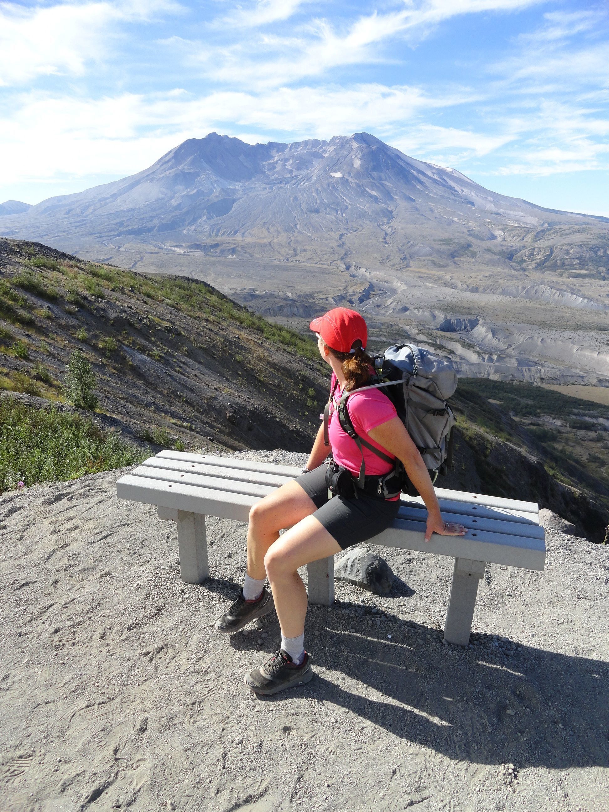
The hardest part about hiking to Harry’s Ridge is not trudging across high dusty slopes under direct sunlight and against strong winds. It’s not the elevation gain and loss that is relatively modest due to this hike’s lofty starting point. The hardest part about hiking to this ridge named for one of St Helens’ most colorful historical personalities is that you won’t be able to keep your attention directed in one direction—nor will you cease from exclaiming, “Wow, these views are amazing!”
Harry’s Ridge projects south from Johnston Ridge to not only offer superb viewing of the Pumice Plain and Mount St. Helens’ crater—but also of massive silver-log-littered Spirit Lake right below it with Mount Adams hovering in the distance. It’s one of the finest views of the volcano-blasted lake. And finally the view north of the jagged tree-denuded jumble of Mount Margaret Backcountry Peaks isn’t too shabby either.
The hike to Harry’s Ridge begins with a traverse across Johnston Ridge. It makes for a great moderate day hike from the observatory. And while this hike can be enjoyed from June through October, shoot for early summer if you can to savor the dazzling wildflowers that will be lining the way. Paintbrush, penstemon, pearly everlasting, lupine, tiger lilies, and more form a mosaic of brilliant colors across an otherwise gray landscape.


Start your hike from the massive parking lot at the Johnston Ridge Observatory at the end of the Spirit lake Memorial Highway (State Route 504). You’ll need to purchase a Monument Pass (available at the Johnston Ridge Observatory) before beginning your hike if you don’t have a Northwest Forest Pass or Interagency Pass. If starting before the observatory is open, be sure to carry your pass with you in lieu of the monument pass wrist band. You can be fined for hiking here without a pass.
Now from a ridgetop elevation of more than 4,000 feet start hiking east on the Boundary Trail (carrying the distinction of being trail no. 1). The way begins paved—part of the interpretive Eruption Trail. At 0.1 mile the Eruption Trail continues right leading back to the Observatory. It’s worth checking out on the return (or start) to help give you a better understanding of the landscape before you and of the tumultuous days leading to, during, and after the 1980 eruption.The Boundary Trail continues left on nicely groomed natural tread heading downhill along Johnston Ridge. The views are continuous and spectacular—Mount St Helens to the right—Coldwater Peak with its blocked summit to the left. A brilliant array of flowers paint the blasted landscape. Young noble firs colonize the ridge’s northern slopes. Every year they get a little bigger—working tenaciously to reforest the land before you. Shade however is still at a premium here—so don’t forget the sun screen and extra water.
Shortly after passing a kiosk and bench used for outdoor programs reach a saddle. Then continue on narrower tread cutting across patches of mountain alder and regaining some lost elevation. At 1.6 miles the way reaches another saddle. Here a section of trail was opened in 2016 bypassing an exposed slope known as the Devils Elbow. The old route had more than a few hikers feeling uneasy along a stretch of steep and intimidating slopes. No worries now as the trail avoids it by jutting over a small rise and returning to the original route in 0.4 mile. Here you can take a short side trail right (part of the original route) to an excellent viewpoint of Harry’s Ridge with Spirit Lake and Mount Adams in the distance. To continue to Harry’s Ridge head left and soon come to a junction with the Truman Trail that veers south across the Pumice Plain.


Here at the trail junction in a small saddle is an area known as the Spillover. The 1980 eruption triggered a landslide that roared into Spirit Lake, creating a massive wave that climbed 800 feet up Harry’s Ridge and spill over this spot. When the wave receded, it swept thousands of trees that were blown down during the blast into the lake. Continue hiking straight on the Boundary Trail traversing a hummocky landscape cloaked with alders and willows and home to scads of ground squirrels and thousands of grasshoppers. Not long after crossing a bridge spanning a gully, reach another junction. The Boundary Trail continues left to a natural arch, Coldwater Peak, and some of the most rugged and spectacular country in the monument.
For Harry’s Ridge head right gently ascending about 350 feet and reaching seismic measuring equipment (don’t disturb) at the highpoint (el. 4,752 feet). Now savor sweeping views to the Mount Margaret backcountry peaks, Johnston Ridge, Mount St Helens and Mount Adams. Directly below is Spirit Lake with its ever shifting flotilla of logs. Greatly altered from the eruption and left without an outlet due to landslide debris; government officials worried of a catastrophic flood if the waters were to break through the damming debris. In 1985 they dug an outlet tunnel beneath Harry’s Ridge discharging water into South Coldwater Creek and maintaining Spirit Lake’s surface level.
Harry Truman whom this ridge is named after owned and lived with his 16 cats at the Mount St Helens Lodge on the south shore of Spirit Lake. Refusing to leave the area after being warned of the dangers of the imminent eruption, the World War I Vet Truman gained folk hero status. “If the mountain goes, I’m going with it,” he was quoted in a newspaper article. On May 18th after living 52 years at the lodge, Truman was buried under a pyroclastic flow—his lodge destroyed and his body never recovered.
Trail Resources:
Map: Green Trails Mount St Helens 332S
Guidebook: Day Hiking Mount St. Helens by Craig Romano and Aaron Theisen (Mountaineers
Books)
Managing Agency: Mount St Helens National Volcanic Monument
http://www.fs.usda.gov/main/mountsthelens
-Craig Romano, is an award-winning author of more than 25 guidebooks with Mountaineers
Books. One of the most prolific trails writers in Washington, he has hiked more than 30,000
miles in the state from the Olympics to the Blues. Visit him at CraigRomano.com